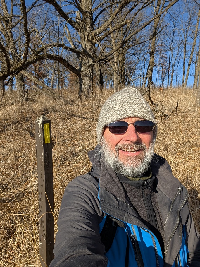
Sometimes I hike a segment of the Ice Age Trail, but I don’t finish it. I leave it half done. I have the best of intentions to return to the segment to finish it off, but then I don’t. Now that I think about it, I’m like this with washing clothes, too. I can wash clothes all day long, and I really truly mean to fold the clean clothes and put them away, but because I run out of time, or because I get distracted by something else, I don’t follow through. It’s just how I am.
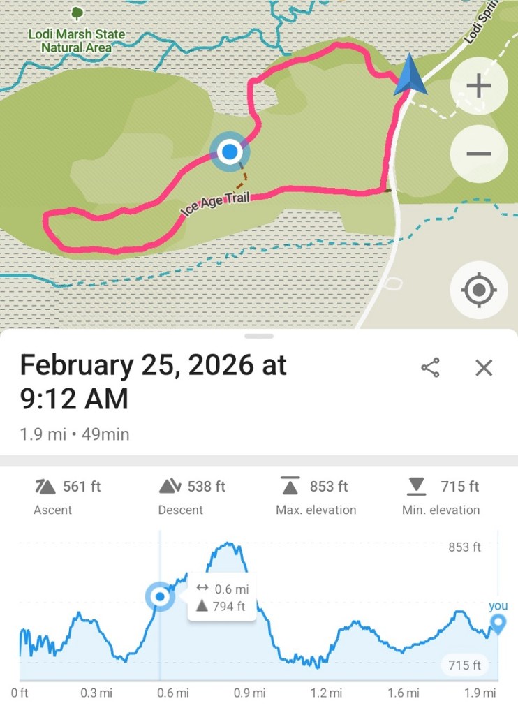
Today was clothes-folding day, metaphorically speaking. I returned to four segments I had left half-done to finally, once and for all finish them so I could check them off my to-do list. I drove up to Lodi Marsh, just south of Lake Wisconsin, to finish off that segment first, then work my way south towards Madison, finishing off the others.
Lodi Marsh Segment
In April 2024 I drove into the country, looking for a good place to take a long walk, when I came to the parking lot for the Lodi Marsh Segment. I parked and followed the trail up the hill to have a look around. Best hike I could have done that day. The view from the top of the hill was magnificent!
Lodi Marsh was only the second time I hiked the Ice Age Trail, back in April 2024. (The first was, I believe, on part of the Cross Plains Segment in March 2024.) I walked the northern half of the trail that goes up to the top of the hill and wanders through the woods along the ridge toward Lodi. When I got to the north end, I took a short cut down to the road and walked back, thinking it would be shorter. And maybe it was, but it was still a mile and a half of schlepping along a paved road with not much to look at, while pickup trucks zoomed past every five minutes. This may have been the defining experience that made me never want to walk another road ever again.
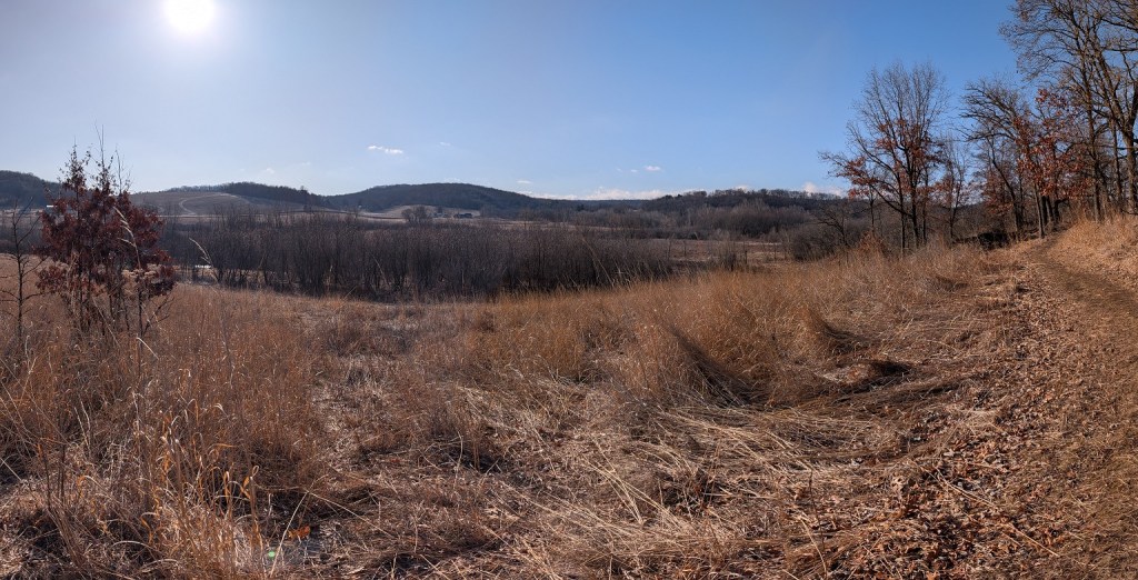
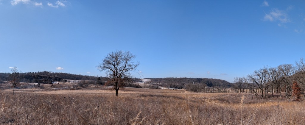
The part of the segment I left unfinished was a small loop to the south of the parking lot. When I returned to finish it today, the temp was 21 deg F and there was a stiff wind blowing across the wetlands. It was strong enough to easily penetrate the leafless treeline. In the shadow of the trees, I had to bundle up my overcoat as tightly as possible and keep moving if I wanted to stay warm, and I desperately wanted to do that.
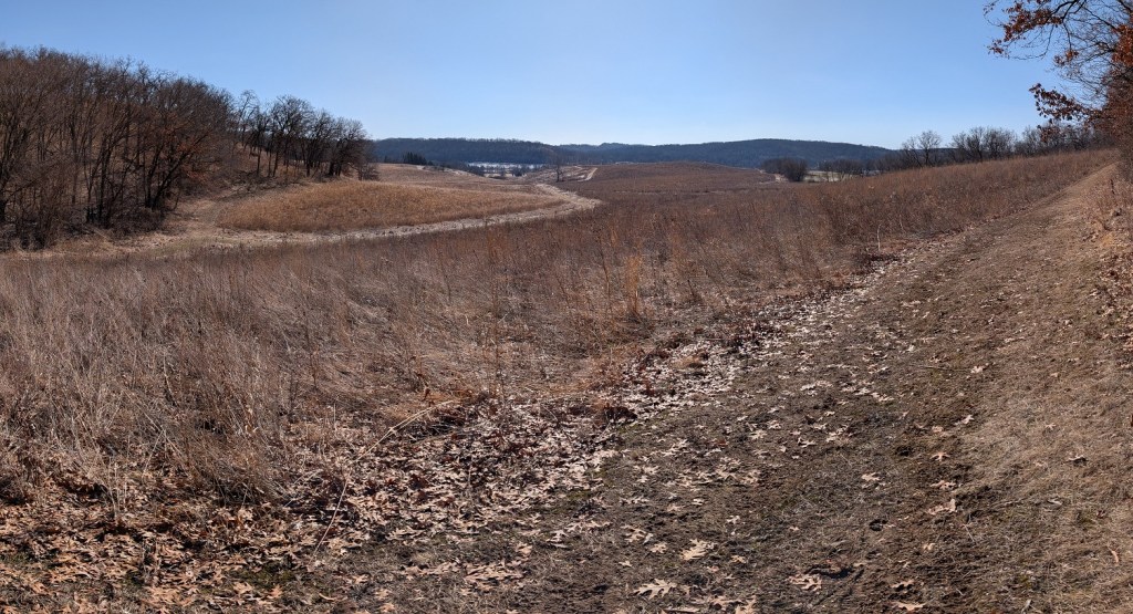
The trail from the parking lot twisted and turned for about a quarter-mile through the treeline of gnarled oaks and dry brown grass. The trail surface was plain dirt, frozen solid in the morning chill. I had an easy time keeping a fast, steady pace over it. After weaving my way through the trees, I followed the trail to the bottom of a gulch, then climbed out of the treeline up to an open meadow.
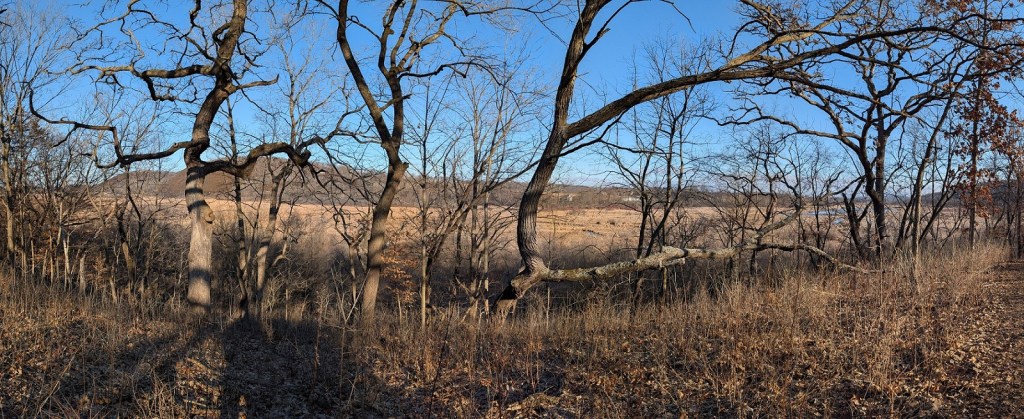
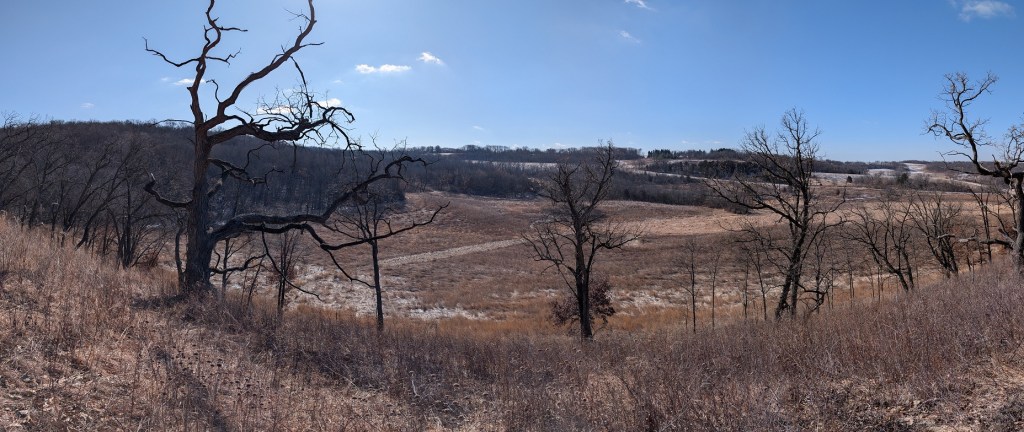
The wind coming across the dry brown prairie grass was biting, but at least the sun was out and the sky was clear. The trail climbed steadily to the top of a tree-covered hill where I got a break from the wind and beautiful views of the surrounding wetlands. The undergrowth on the south side of the hill had been cleared in the recent past and stacked up in tall piles, waiting to be burned.
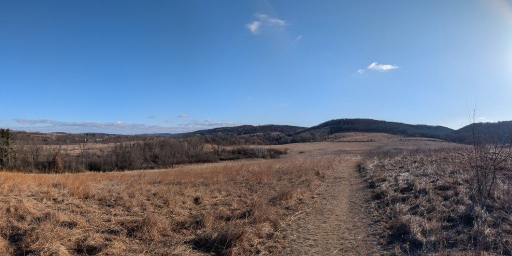
Around the south side of the hill, the trail followed a service road back to the main road. The service road was wide and level and easy to walk. At the end of the service road, I found a blazed trail that ran along the top of the berm above the ditch that looped back to the parking lot. I love it when they do this. I was able to walk back to my car without being forced to tramp down the paved road, trying to avoid oncoming traffic.
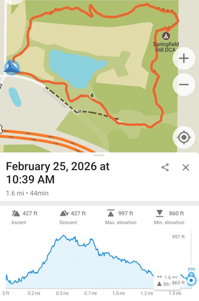
Springfield Hill Segment
I considered the Springfield Hill Segment “unfinished” because it’s a five-minute drive north of the Indian Lake Segment, which I visited last September. I simply didn’t bother to check it out while I was there.
It’s kind of a weird segment. Most segments of the IAT start from one end of a parcel of land, weave through it a bit to give you a good look at all the different parts of it, then come out the other end. The trail at Springfield Hill, however, starts and ends in the same corner of the parcel; I literally made a big circle around the meadow in the middle. If I were a through-hiker, I think I’d be sorely tempted to bypass this segment instead of adding a mile and a half to the day’s walk by going nowhere.
If I’d done that, though, I would’ve missed out on a pleasant walk around a relaxing plot of ground. The trail swung north around the border of a very pretty field of prairie grass before it switched back and forth several times across the face of a hill to get to the top. I’m guessing this is the Springfield Hill of the segment’s name. The trail followed a long, sinuous curve along the top of the hill, giving a beautiful view of the grassy fields and thick forests below.
Then the trail switched down the other side of the hill before it ducked into a wooded area overgrown by Buckthorn, where I couldn’t see much of anything for a while. There’s a small camp site for hikers tucked in the woods back here. It’d be fun to come back in the future to spend a day exploring the trails around Indian Lake, then spend the night at Springfield Hill.
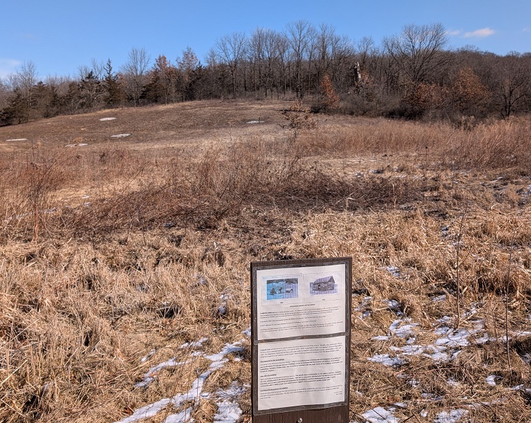
When I came out of the woods, I was in a narrow meadow which was apparently the homestead of this piece of land. A sign posted near the trail indicated that the cabin I should’ve been looking at was the original home of the farmer who lived here, Frederick Hahn. Only there was no cabin. The sign was dated 2020, so at some point in the last five years or so, someone must have removed it, hopefully to preserve it.
The trail continues along the southern border of the field, to return to the parking lot in the southwest corner of the park.
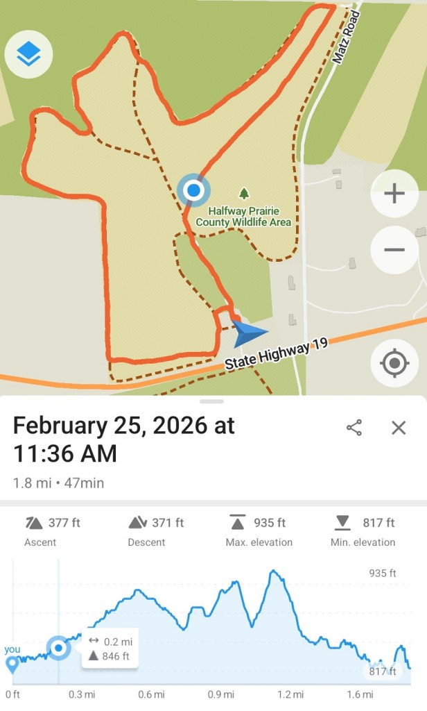
Halfway Prairie

The Halfway Prairie Wildlife Area appears to be part of the Indian Lake County Park, and both are part of the Dane County Parks system, but Halfway Prairie is on the other side of State Highway 19 from the lake. When I visited Indian Lake last September, I stayed on the south side of the highway.
The section of the Ice Age Trail which runs through Halfway Prairie is very short. That’s probably why I ignored it last fall. There are many connecting trails crisscrossing the prairie, though, so I wouldn’t have to make an out-and-back trip to complete this hike.
Some of the walls of the house built on the homestead in 1900-ish are still standing on the hill near the parking lot. Sadly, the house was gutted by a fire in 1949, so all that remains is the idea of a house. A barn still stands to the east. It looked old enough to be original to the homestead but the signs around the ruins didn’t say for sure.
I walked up the IAT to the northeast corner of the meadow. Boom, done! Then, because it was getting warm and the sun felt good, I followed a trail around the edges of the meadow to loop back to the parking lot. It would’ve normally been a very easy hike, but due to the warm(er) temps — it got up to 28 degrees F while I was there — and the sun beating down from a clear sky, the top half-inch of soil was softened into a slippery layer of mud that left me windmilling to catch my balance more than once.
Cross Plains
The very first segment of the Ice Age Trail I visited was the part of the Cross Plains Segment that started from the parking lot at the end of North Birch Trail south of Cross Plains and winded through the woods on the hillside that loomed over a narrow farmer’s field in the valley below. The trail made a hairpin turn around the end of the field and doubled back on the other side of the valley. There was a shortcut to loop back to the parking lot. I enjoyed that hike so much, I went back a couple times to re-visit that section.
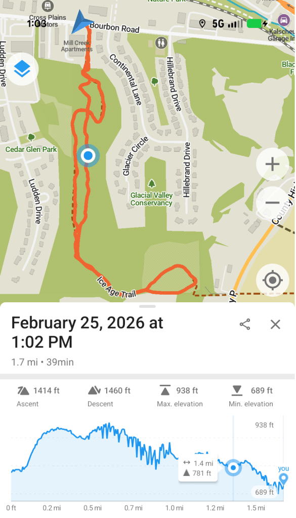
There are many other sections to the Cross Plains Segment, scattered across the countryside around the village of Cross Plains. I had hiked all of them except for a section that ran from a trailhead on Stagecoach Road across the Mammoth’s Back Preserve, then across County Highway P and into the Glacial Valley Conservancy.
I parked my car in the lot on Stagecoach Road, bundled up and got ready to start hiking toward the village. The Mammoth’s Back Preserve appeared to be an open field, with an oddly artificial-looking hill about fifty to seventy-five feet tall standing on the southern edge of the field. The trail skirted around the base of the hill to the east. From the parking lot, I couldn’t see beyond it. It wasn’t until after I bundled up and started hiking that I could see, on the other side of the hill, it was a bare corn field that stretched on forever. Well, a mile, at least. Standing in the middle of a flat cornfield with the wind whipping my face, my enthusiasm for completing this section of the trail dropped to zero. I turned tail and headed back to the van.
I couldn’t drive away from Cross Plains without at least taking a look at the Glacial Valley Conservancy, just to see what that was about. It was in the village between two housing developments, but it might be nice. Pleasant surprise! — it was.
The approach from the road was kind of odd. There was a sign marking the entrance but the path to the conservancy went through the middle of a housing development, along the edges of several back yards. Creeping around behind other people’s houses, practically in their yards, felt weird, but maybe they’re used to it by now. I just stared straight ahead and barged through anyway.
The entrance was a short flight of heavy timber stairs up the side of a steep hill. At the top of the stairs, a narrow trail switched back and forth to the top of the hill. I followed the Ice Age Trail through the tall leafless trees, eventually emerging on the western slope of the hill and a view of the development below me. There was a bench where hikers could stop to rest and to admire the rooftops of the houses below. I supposed that’s sort of scenic. I kept on hiking.
The IAT crossed several other trails as it wandered through the park. I used those trails to loop back and get a more complete view of the conservancy on my return to the car. A high prairie at the southern end of the conservancy was effectively the end of my hike; the IAT descended to the highway from there, and I had no inclination to scramble down the hill, only to climb right back up again.
AND DONE!
I only walked seven miles in all today, but with the driving in between the hikes I was out all morning from seven-thirty until about two o’clock in the afternoon. Got back home just in time to get a nap!


Leave a comment